Compare Scissurella prendrevillei
| toggle to add to compare list |
Taxonomy
Family: SCISSURELLIDAE Full Classification: Mollusca (Phylum) > Gastropoda (Class) > Vetigastropoda (Subclass) > Lepetelllida (Order) > Scissurelloidea (Superfamily) > Scissurellidae (Family) > Scissurella (Genus) > prendrevillei (Species) Genus Synonyms: =Maxwellella Bandel, 1998 =Praescissurella Lozouet, 1998 =Reussella Bandel, 1998 =Schismope Jeffreys, 1856 =Woodwardia Crosse & P. Fischer, 1861 Synonymised Names: =Scissurella fairchildi Powell, 1933 =Scissurella marshalli Bandel, 1998 =Scissurella stellae C.A. Fleming, 1948 |
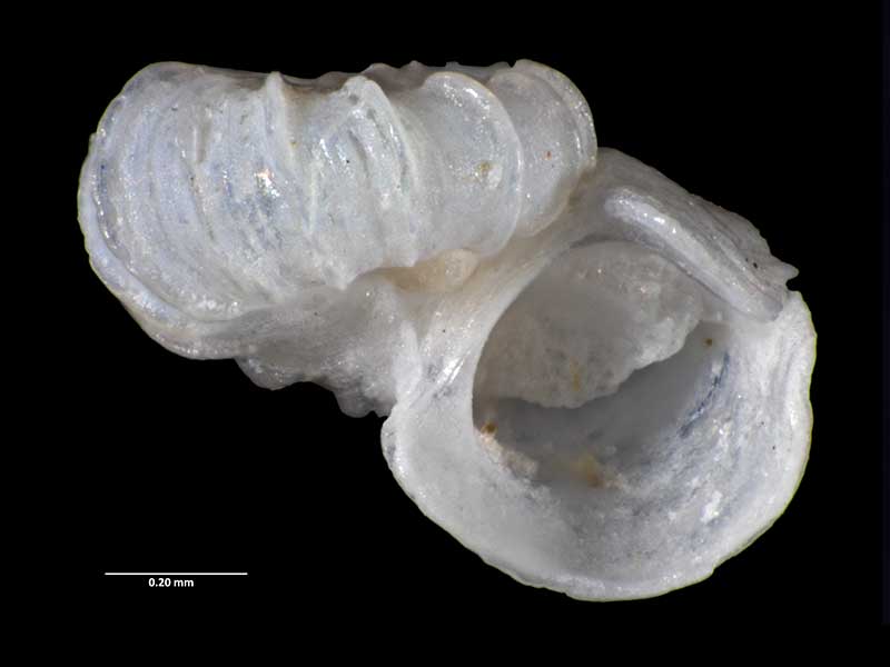
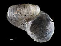
Images: Scissurella prendrevillei Powell, 1933

Holotype, collected Feb 1933, off Owenga, Chatham Islands, NZ (MA70701). 1.2mm. © Auckland Museum (CC-BY)
Paratype, collected Jun 1893, off Bounty Islands, NZ (MA72369). © Auckland Museum (CC-BY)
Taxonomy
Family: SCISSURELLIDAE Full Classification: Mollusca (Phylum) > Gastropoda (Class) > Vetigastropoda (Subclass) > Lepetelllida (Order) > Scissurelloidea (Superfamily) > Scissurellidae (Family) > Scissurella (Genus) > prendrevillei (Species) Genus Synonyms: =Maxwellella Bandel, 1998 =Praescissurella Lozouet, 1998 =Reussella Bandel, 1998 =Schismope Jeffreys, 1856 =Woodwardia Crosse & P. Fischer, 1861 Synonymised Names: =Scissurella fairchildi Powell, 1933 =Scissurella marshalli Bandel, 1998 =Scissurella stellae C.A. Fleming, 1948 |
Details: Scissurella prendrevillei Powell, 1933
Size/Grows to:
Width 1.2mm, Height 0.7mm
Distribution:
Three Kings, North, South Island, Fiordland and Chatham Islands. 0-805 metres
Geographical Range:
ACFMAnE.
Notes:
Species Links
Distribution Map
References and Publications
- Marshall, B.A. 2002 Some Recent Scissurellids from the New Zealand region and remarks on some Scissurellid genus group names (Mollusca : Gastropoda : Vetigastropoda), Molluscan Research, 22 (p.168)
- Bandel, K. 1998 Scissurellidae als Modell für die Variationsbreite einer Natürlichen Einheit der Schlitzbandschnecken (Mollusca; Archaeogastropoda), Mitteilungen aus dem Geologisch-paläontogischen Institut der Universität Hamburg, 81 (p.12)
- Powell, A.W.B. 1979 New Zealand Mollusca: Marine, Land and Freshwater Shells, Collins, Auckland (p.34)
- Powell, A.W.B. 1933 The marine Mollusca of the Chatham Islands, Records of the Auckland Institute and Museum, 1 (p.193) Original Description
*98 © Museum of New Zealand Te Papa Tongarewa (CC-BY-NC-ND)
Key to Geographical Ranges

The symbols K.A.C.F.M.An. are used to indicate the geographical range of the species.
They have been adopted to give an approximation of the range of each species within New Zealand.
K=
Kermadec Islands
A=
Aupourian - Kaipara Harbour, north around North Cape, encompassing the Three Kings Islands and south to East Cape
C=
Cookian - Lower North Island and the northern part of the South Island
F=
Forsterian - Otago, Fiordland and Stewart Island
M=
Moriorian - Chatham Islands, Pitt Island
An=
Antipodean - Subantarctic Islands of New Zealand
Fw =
Freshwater
L =
Land
N =
North Island
S =
South Island
E =
Endemic
I =
Introduced
R =
Recent
Sf =
Subfossil
Fo =
Fossil
Recently Viewed
Compare Species (
/6)