Compare Prototyphis eos
| toggle to add to compare list |
Taxonomy
Family: Subfamily: MURICIDAE: TRIPTEROTYPHINAE Full Classification: Mollusca (Phylum) > Gastropoda (Class) > Caenogastropoda (Subclass) > Neogastropoda (Order) > Muricoidea (Superfamily) > Muricidae (Family) > Tripterotyphinae (Subfamily) > Prototyphis (Genus) > eos (Species) Genus Synonyms: =Pterotyphis (Prototyphis) Ponder, 1972 Synonymised Names: =Murex (Pteronotus) eos Hutton, 1873 =Murex eos Hutton, 1873 =Prototyphis eos eos (Hutton, 1873) accepted, alternate representation =Pterynotus (Pterochelus) angasi powelli C.A. Fleming, 1962 |
Images: Prototyphis eos (Hutton, 1873)
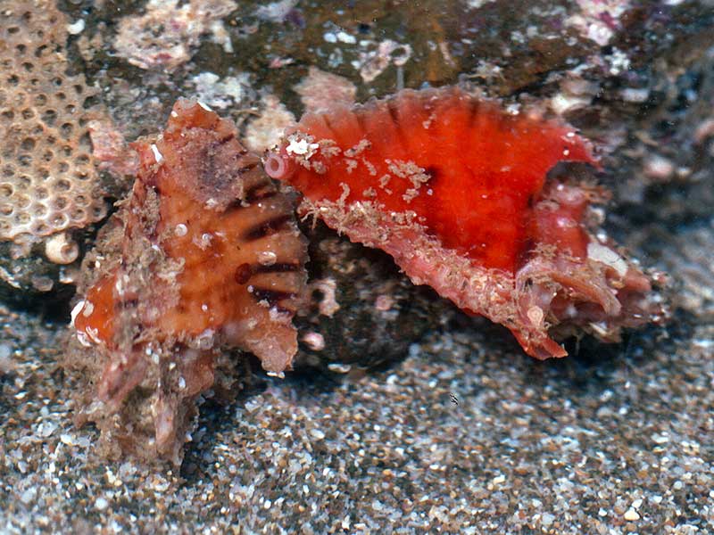
From about 15 metres, off Bland Bay, Northland. They are occasionally seen under large rock slabs or in crevices
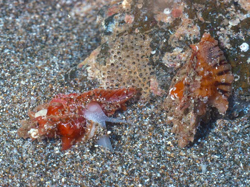
From about 15 metres, off Bland Bay, Northland, NZ
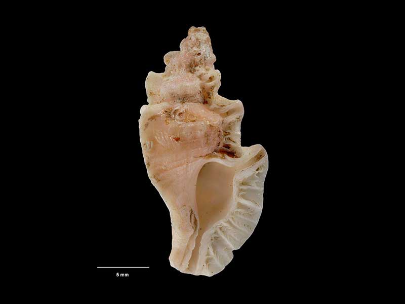
Lectotype, collected Bay of Islands (no other data), NZ (M.000067). ~24mm. © Museum of New Zealand Te Papa Tongarewa (CC-BY-NC-ND)
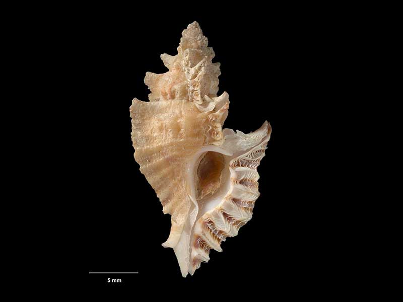
Collected 15 Feb 1986, S side of Rosemary Rock, Princes Island, NZ (M.305387). ~25mm. © Museum of New Zealand Te Papa Tongarewa (CC-BY-NC-ND)
Taxonomy
Family: Subfamily: MURICIDAE: TRIPTEROTYPHINAE Full Classification: Mollusca (Phylum) > Gastropoda (Class) > Caenogastropoda (Subclass) > Neogastropoda (Order) > Muricoidea (Superfamily) > Muricidae (Family) > Tripterotyphinae (Subfamily) > Prototyphis (Genus) > eos (Species) Genus Synonyms: =Pterotyphis (Prototyphis) Ponder, 1972 Synonymised Names: =Murex (Pteronotus) eos Hutton, 1873 =Murex eos Hutton, 1873 =Prototyphis eos eos (Hutton, 1873) accepted, alternate representation =Pterynotus (Pterochelus) angasi powelli C.A. Fleming, 1962 |
Details: Prototyphis eos (Hutton, 1873)
Size/Grows to:
Height 30mm, Width 16mm
Distribution:
Northland east coast to Bay of Plenty and East Cape
Geographical Range:
AE.
Notes:
Species Links
Distribution Map
References and Publications
- Mead, K., Carson, K., Raven, J.L., Couper, J., Elliot, M., Elliot, C., Bracegirdle, S. Nov/2021 Notes on NZ Collected Species, Cookia, 33 (p.18)
- Beu, A.G., Maxwell, P.A. 1990 Cenozoic Mollusca of New Zealand, New Zealand Geological Survey, 58 (p.358)
- Cumber, R.A. Nov/1980 The Pterotyphis eos eos (Hutton) wash-up at Paihia in 1969, Poirieria, 10(6) (p.94)
- Powell, A.W.B. 1979 New Zealand Mollusca: Marine, Land and Freshwater Shells, Collins, Auckland (p.171)
- Fleming, C.A. 1962 The Genus Pterynotus Swainson (Gastropoda, Family Muricidae) in New Zealand and Norfolk Island, Transactions of the Royal Society of New Zealand, 2(14) (p.115)
- Hutton, F.W. 1873 Catalogue of the Marine Mollusca of New Zealand, with diagnoses of the species, Dominion Museum (NZ) (p.8) Original Description
*98 © Museum of New Zealand Te Papa Tongarewa (CC-BY-NC-ND)
Key to Geographical Ranges

The symbols K.A.C.F.M.An. are used to indicate the geographical range of the species.
They have been adopted to give an approximation of the range of each species within New Zealand.
K=
Kermadec Islands
A=
Aupourian - Kaipara Harbour, north around North Cape, encompassing the Three Kings Islands and south to East Cape
C=
Cookian - Lower North Island and the northern part of the South Island
F=
Forsterian - Otago, Fiordland and Stewart Island
M=
Moriorian - Chatham Islands, Pitt Island
An=
Antipodean - Subantarctic Islands of New Zealand
Fw =
Freshwater
L =
Land
N =
North Island
S =
South Island
E =
Endemic
I =
Introduced
R =
Recent
Sf =
Subfossil
Fo =
Fossil
Recently Viewed

Compare Species (
/6)