Compare Notoplax mariae
| toggle to add to compare list |
Taxonomy
Family: ACANTHOCHITONIDAE Full Classification: Mollusca (Phylum) > Polyplacophora (Class) > Neoloricata (Subclass) > Chitonida (Order) > Acanthochitonina (Suborder) > Cryptoplacoidea (Superfamily) > Acanthochitonidae (Family) > Notoplax (Genus) > mariae (Species) Genus Synonyms: =Acanthochites (Notoplax) H. Adams, 1862 =Acanthochiton (Notoplax) H. Adams, 1862 =Cryptoplax (Notoplax) H. Adams, 1862 Synonymised Names: =Acanthochites (Loboplax) mariae Webster, 1908 =Loboplax stewartiana Thiele, 1909 =Notoplax (Amblyplax) brookesi Ashby, 1929 =Notoplax (Amblyplax) mariae (Webster, 1908) =Notoplax (Amblyplax) mariae haurakiensis Ashby, 1926 =Notoplax brookesi Ashby, 1929 =Notoplax brookesi var. fortior Iredale & Hull, 1931 |
Images: Notoplax mariae (Webster, 1908)
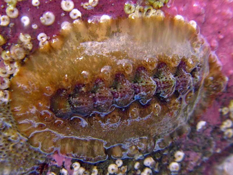
Henderson Bay, Far North, living under a rock in the low intertidal zone. Reproduced courtesy of iNaturalist.nz ©tangatawhenua
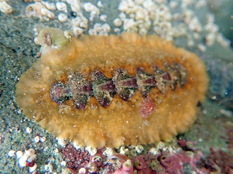
Alive under rock at low tide, Henderson Bay, Far North, NZ. ~30mm
Taxonomy
Family: ACANTHOCHITONIDAE Full Classification: Mollusca (Phylum) > Polyplacophora (Class) > Neoloricata (Subclass) > Chitonida (Order) > Acanthochitonina (Suborder) > Cryptoplacoidea (Superfamily) > Acanthochitonidae (Family) > Notoplax (Genus) > mariae (Species) Genus Synonyms: =Acanthochites (Notoplax) H. Adams, 1862 =Acanthochiton (Notoplax) H. Adams, 1862 =Cryptoplax (Notoplax) H. Adams, 1862 Synonymised Names: =Acanthochites (Loboplax) mariae Webster, 1908 =Loboplax stewartiana Thiele, 1909 =Notoplax (Amblyplax) brookesi Ashby, 1929 =Notoplax (Amblyplax) mariae (Webster, 1908) =Notoplax (Amblyplax) mariae haurakiensis Ashby, 1926 =Notoplax brookesi Ashby, 1929 =Notoplax brookesi var. fortior Iredale & Hull, 1931 |
Details: Notoplax mariae (Webster, 1908)
Size/Grows to:
Length 35mm, Width 18mm
Distribution:
North, South and Stewart Island. Low tide to about 40 metres
Geographical Range:
ACF
Notes:
Species Links
Distribution Map
References and Publications
- Powell, A.W.B. 1979 New Zealand Mollusca: Marine, Land and Freshwater Shells, Collins, Auckland (p.30)
Key to Geographical Ranges

The symbols K.A.C.F.M.An. are used to indicate the geographical range of the species.
They have been adopted to give an approximation of the range of each species within New Zealand.
K=
Kermadec Islands
A=
Aupourian - Kaipara Harbour, north around North Cape, encompassing the Three Kings Islands and south to East Cape
C=
Cookian - Lower North Island and the northern part of the South Island
F=
Forsterian - Otago, Fiordland and Stewart Island
M=
Moriorian - Chatham Islands, Pitt Island
An=
Antipodean - Subantarctic Islands of New Zealand
Fw =
Freshwater
L =
Land
N =
North Island
S =
South Island
R =
Recent
Sf =
Subfossil
Fo =
Fossil
Recently Viewed

Compare Species (
/6)