Compare Cellana strigilis
| toggle to add to compare list |
Taxonomy
Family: NACELLIDAE Full Classification: Mollusca (Phylum) > Gastropoda (Class) > Patellogastropoda (Subclass) > Lottioidea (Superfamily) > Nacellidae (Family) > Cellana (Genus) > strigilis (Species) Genus Synonyms: =Bertinia Jousseaume, 1883 =Granopatella Pallary, 1920 =Helcion (Helcioniscus) Dall, 1871 =Helcioniscus Dall, 1871 =Nacella (Cellana) H. Adams, 1869 Synonymised Names: =Cellana strigilis flemingi Powell, 1955 =Cellana strigilis redimiculum (Reeve, 1854) =Cellana strigilis strigilis (Hombron & Jacquinot, 1841) =Nacella (Patinigera) illuminata Suter, 1913 =Patella illuminata Gould, 1846 =Patella pottsi Hutton, 1873 =Patella redimiculum Reeve, 1854 =Patella strigilis Hombron & Jacquinot, 1841 |
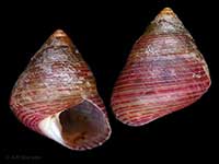
Images: Cellana strigilis (Hombron & Jacquinot, 1841)
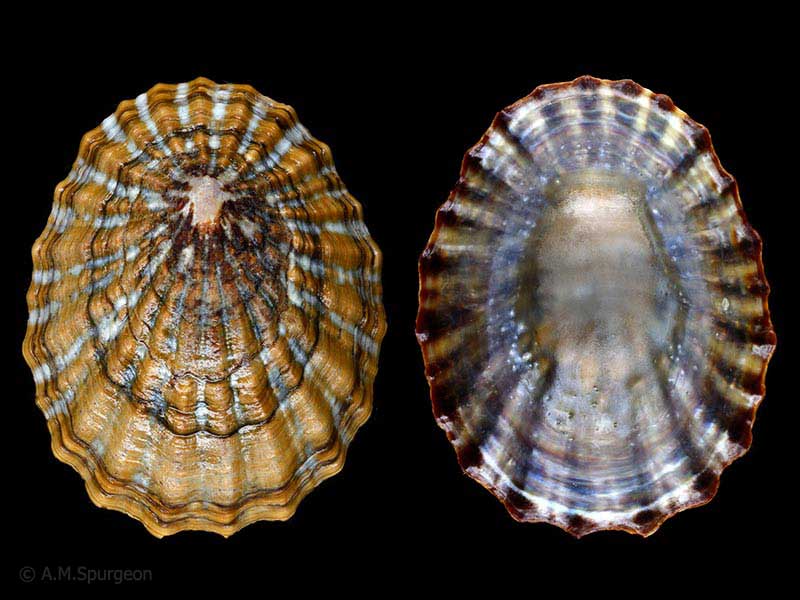
(redimiculum form) - Port William, Stewart Island, NZ. 44mm
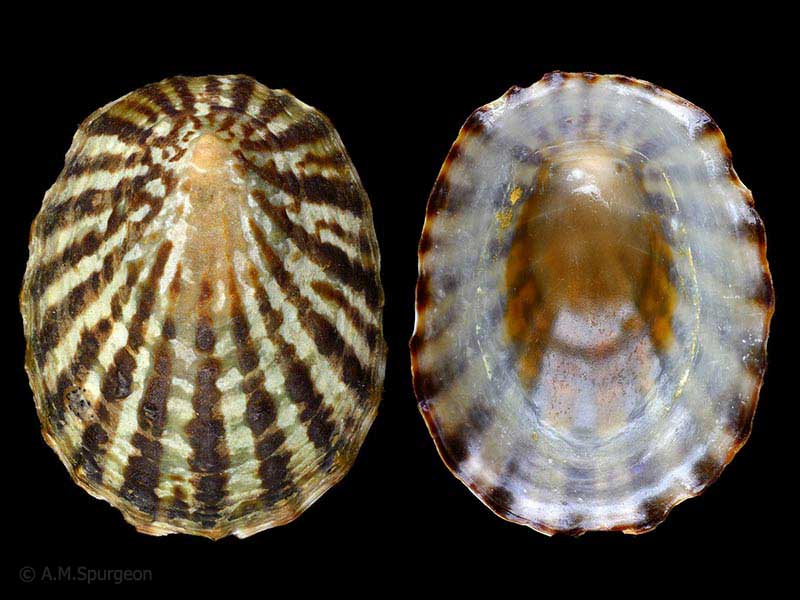
(flemingi form) - Snares Islands. 50mm
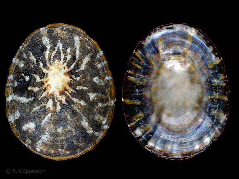
Campbell Island. 54mm
Taxonomy
Family: NACELLIDAE Full Classification: Mollusca (Phylum) > Gastropoda (Class) > Patellogastropoda (Subclass) > Lottioidea (Superfamily) > Nacellidae (Family) > Cellana (Genus) > strigilis (Species) Genus Synonyms: =Bertinia Jousseaume, 1883 =Granopatella Pallary, 1920 =Helcion (Helcioniscus) Dall, 1871 =Helcioniscus Dall, 1871 =Nacella (Cellana) H. Adams, 1869 Synonymised Names: =Cellana strigilis flemingi Powell, 1955 =Cellana strigilis redimiculum (Reeve, 1854) =Cellana strigilis strigilis (Hombron & Jacquinot, 1841) =Nacella (Patinigera) illuminata Suter, 1913 =Patella illuminata Gould, 1846 =Patella pottsi Hutton, 1873 =Patella redimiculum Reeve, 1854 =Patella strigilis Hombron & Jacquinot, 1841 |
Details: Cellana strigilis (Hombron & Jacquinot, 1841)
Size/Grows to:
Length 80mm, Width 68mm, Height 32mm
Distribution:
Stewart Island, Foveaux Strait, and the east coast of the South Island up to Kaikoura. Also Auckland, Snares and Campbell Islands
Geographical Range:
CFAn
Notes:
Species Links
Distribution Map
References and Publications
- Reisser, C.M.O., Marshall, B.A., Gardner, J.P.A. 2012 A morphometric approach supporting genetic results in the taxonomy of the New Zealand limpets of the Cellana strigilis complex (Mollusca: Patellogastropoda: Nacellidae), Invertebrate Systematics, 26 (p.197)
- Penniket, J.R. Aug/1988 The Genus Cellana in New Zealand, Poirieria, 15(5) (p.14)
- Powell, A.W.B. 1979 New Zealand Mollusca: Marine, Land and Freshwater Shells, Collins, Auckland (p.44)
- Hutton, F.W. 1873 Catalogue of the Marine Mollusca of New Zealand, with diagnoses of the species, Dominion Museum (NZ) (p.44)
*98 © Museum of New Zealand Te Papa Tongarewa (CC-BY-NC-ND)
Key to Geographical Ranges

The symbols K.A.C.F.M.An. are used to indicate the geographical range of the species.
They have been adopted to give an approximation of the range of each species within New Zealand.
K=
Kermadec Islands
A=
Aupourian - Kaipara Harbour, north around North Cape, encompassing the Three Kings Islands and south to East Cape
C=
Cookian - Lower North Island and the northern part of the South Island
F=
Forsterian - Otago, Fiordland and Stewart Island
M=
Moriorian - Chatham Islands, Pitt Island
An=
Antipodean - Subantarctic Islands of New Zealand
Fw =
Freshwater
L =
Land
N =
North Island
S =
South Island
R =
Recent
Sf =
Subfossil
Fo =
Fossil
Compare Species (
/6)