Compare Semicassis thomsoni
| toggle to add to compare list |
Taxonomy
Family: Subfamily: CASSIDAE: PHALIINAE Full Classification: Mollusca (Phylum) > Gastropoda (Class) > Caenogastropoda (Subclass) > Littorinimorpha (Order) > Tonnoidea (Superfamily) > Cassidae (Family) > Phaliinae (Subfamily) > Semicassis (Genus) > thomsoni (Species) Genus Synonyms: =Cassis (Semicassis) Mörch, 1852 =Phalium (Semicassis) Mörch, 1852 =Phalium (Xenogalea) Iredale, 1927 =Semicassis (Xenophalium) Iredale, 1927 =Xenogalea Iredale, 1927 =Xenophalium Iredale, 1927 Synonymised Names: =Cassis (Casmaria) thomsoni Brazier, 1876 =Cassis thomsoni Brazier, 1876 =Semicassis (Semicassis) thomsoni (Brazier, 1876) accepted, alternate representation =Xenogalea thomsoni (Brazier, 1876) =Xenogalea thomsoni palinodia Iredale, 1931 |
Images: Semicassis thomsoni (Brazier, 1876)
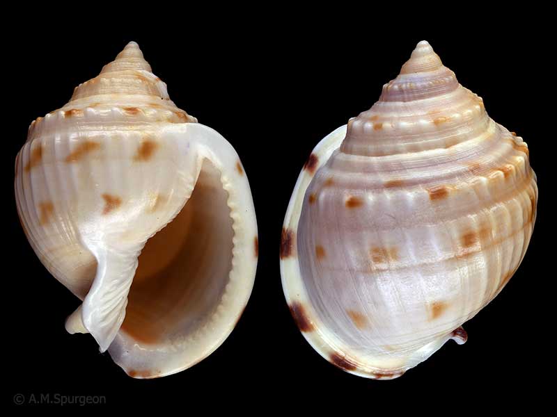
From the east coast, Far North, NZ. 61mm
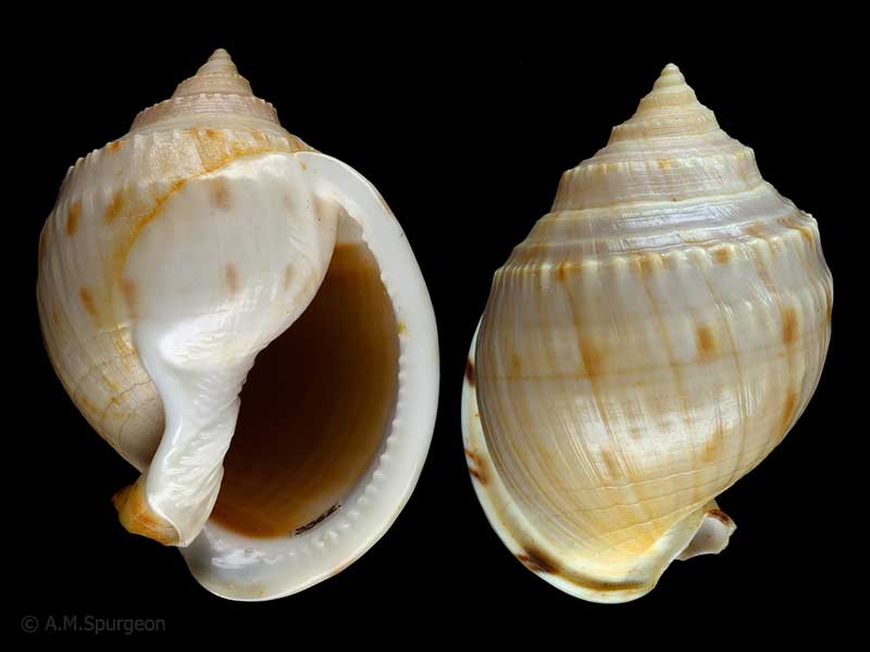
Dredged off Northland, NZ. 62mm
Taxonomy
Family: Subfamily: CASSIDAE: PHALIINAE Full Classification: Mollusca (Phylum) > Gastropoda (Class) > Caenogastropoda (Subclass) > Littorinimorpha (Order) > Tonnoidea (Superfamily) > Cassidae (Family) > Phaliinae (Subfamily) > Semicassis (Genus) > thomsoni (Species) Genus Synonyms: =Cassis (Semicassis) Mörch, 1852 =Phalium (Semicassis) Mörch, 1852 =Phalium (Xenogalea) Iredale, 1927 =Semicassis (Xenophalium) Iredale, 1927 =Xenogalea Iredale, 1927 =Xenophalium Iredale, 1927 Synonymised Names: =Cassis (Casmaria) thomsoni Brazier, 1876 =Cassis thomsoni Brazier, 1876 =Semicassis (Semicassis) thomsoni (Brazier, 1876) accepted, alternate representation =Xenogalea thomsoni (Brazier, 1876) =Xenogalea thomsoni palinodia Iredale, 1931 |
Details: Semicassis thomsoni (Brazier, 1876)
Size/Grows to:
Height 80mm, Width 55mm
Distribution:
Off east coast Northland to Bay of Plenty, New Zealand. Also Australia
Geographical Range:
A
Notes:
Species Links
Distribution Map
References and Publications
- Raven, J.L. Nov/2011 Notes on New Zealand collected species, Cookia, 23 (p.17)
- Powell, A.W.B. 1979 New Zealand Mollusca: Marine, Land and Freshwater Shells, Collins, Auckland (p.160)
- Powell, A.W.B. 1976 On the considerable influx of warm water molluscs that have invaded northern New Zealand waters within recent years, Records of the Auckland Institute and Museum, 13 (p.160)
- Powell, A.W.B. 1964 New Zealand Molluscan Systematics with Descriptions of New Species: Part 4, Records of the Auckland Institute and Museum, 6(1) (p.13)
Key to Geographical Ranges

The symbols K.A.C.F.M.An. are used to indicate the geographical range of the species.
They have been adopted to give an approximation of the range of each species within New Zealand.
K=
Kermadec Islands
A=
Aupourian - Kaipara Harbour, north around North Cape, encompassing the Three Kings Islands and south to East Cape
C=
Cookian - Lower North Island and the northern part of the South Island
F=
Forsterian - Otago, Fiordland and Stewart Island
M=
Moriorian - Chatham Islands, Pitt Island
An=
Antipodean - Subantarctic Islands of New Zealand
Fw =
Freshwater
L =
Land
N =
North Island
S =
South Island
R =
Recent
Sf =
Subfossil
Fo =
Fossil
Recently Viewed
Compare Species (
/6)