Compare Babelomurex lischkeanus
| toggle to add to compare list |
Taxonomy
Family: Subfamily: MURICIDAE: CORALLIOPHILINAE Full Classification: Mollusca (Phylum) > Gastropoda (Class) > Caenogastropoda (Subclass) > Neogastropoda (Order) > Muricoidea (Superfamily) > Muricidae (Family) > Coralliophilinae (Subfamily) > Babelomurex (Genus) > lischkeanus (Species) Synonymised Names: =Latiaxis (Toreuma) lischkeanus (Dunker, 1882) =Latiaxis lischkeanus (Dunker, 1882) accepted, alternate representation =Rapana lischkeana Dunker, 1882 =Tolema australis Laseron, 1955 =Tolema peregrina Powell, 1947 |
Images: Babelomurex lischkeanus (Dunker, 1882)
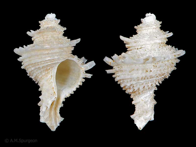
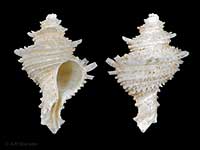
Trawled in the Bay of Plenty. 45mm
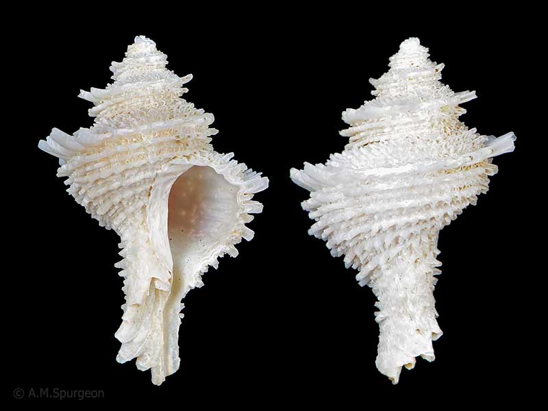
Trawled in the Bay of Plenty. 48mm
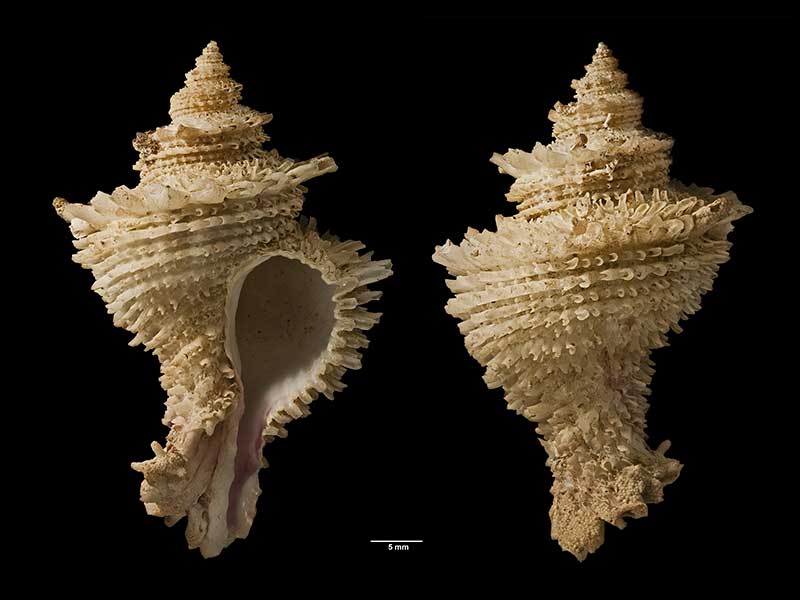
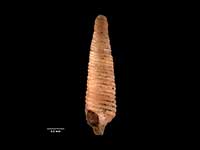
Holotype of Tolema peregrina Powell, 1947, trawled in 37-46 metres, Hauraki Gulf, NZ (MA71138). © Auckland Museum (CC-BY)
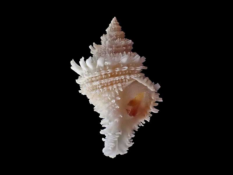
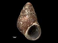
Dredged in 35 metres, east coast Coromandel, NZ. Courtesy of Claire Elliot
Taxonomy
Family: Subfamily: MURICIDAE: CORALLIOPHILINAE Full Classification: Mollusca (Phylum) > Gastropoda (Class) > Caenogastropoda (Subclass) > Neogastropoda (Order) > Muricoidea (Superfamily) > Muricidae (Family) > Coralliophilinae (Subfamily) > Babelomurex (Genus) > lischkeanus (Species) Synonymised Names: =Latiaxis (Toreuma) lischkeanus (Dunker, 1882) =Latiaxis lischkeanus (Dunker, 1882) accepted, alternate representation =Rapana lischkeana Dunker, 1882 =Tolema australis Laseron, 1955 =Tolema peregrina Powell, 1947 |
Details: Babelomurex lischkeanus (Dunker, 1882)
Size/Grows to:
Height 62mm, Width 41mm
Distribution:
North Island, Outer Hauraki Gulf to Bay of Plenty and New Plymouth. Also Japan, South China Sea, Philippines and Queensland to Victoria, Australia
Geographical Range:
KA
Notes:
Species Links
Distribution Map
References and Publications
- Marshall, B.A., Oliverio, M. 2009 The Recent Coralliophilinae of the New Zealand region, with descriptions of two new species (Gastropoda: Neogastropoda: Muricidae), Molluscan Research, 29(3) (p.156)
- Powell, A.W.B. 1979 New Zealand Mollusca: Marine, Land and Freshwater Shells, Collins, Auckland (p.182)
*98 © Museum of New Zealand Te Papa Tongarewa (CC-BY-NC-ND)
Key to Geographical Ranges

The symbols K.A.C.F.M.An. are used to indicate the geographical range of the species.
They have been adopted to give an approximation of the range of each species within New Zealand.
K=
Kermadec Islands
A=
Aupourian - Kaipara Harbour, north around North Cape, encompassing the Three Kings Islands and south to East Cape
C=
Cookian - Lower North Island and the northern part of the South Island
F=
Forsterian - Otago, Fiordland and Stewart Island
M=
Moriorian - Chatham Islands, Pitt Island
An=
Antipodean - Subantarctic Islands of New Zealand
Fw =
Freshwater
L =
Land
N =
North Island
S =
South Island
R =
Recent
Sf =
Subfossil
Fo =
Fossil
Compare Species (
/6)