Compare Glaucus atlanticus
| toggle to add to compare list |
Taxonomy
Family: GLAUCIDAE Full Classification: Genus Synonyms: =Dadone Gistel, 1848 Synonymised Names: =Doris radiata Gmelin, 1791 =Glaucus distichoicus d'Orbigny, 1837 =Glaucus flagellum Blumenblach, 1803 =Glaucus hexapterigius Cuvier, 1805 =Glaucus lineatus Reinhardt & Bergh, 1864 =Glaucus longicirrhus Reinhardt & Bergh, 1864 |
Images: Glaucus atlanticus Forster, 1777
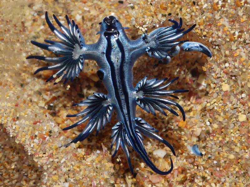
Washed up on Henderson Bay, Far North. Photo 3001222. 30mm. Reproduced courtesy of iNaturalist.nz ©tangatawhenua
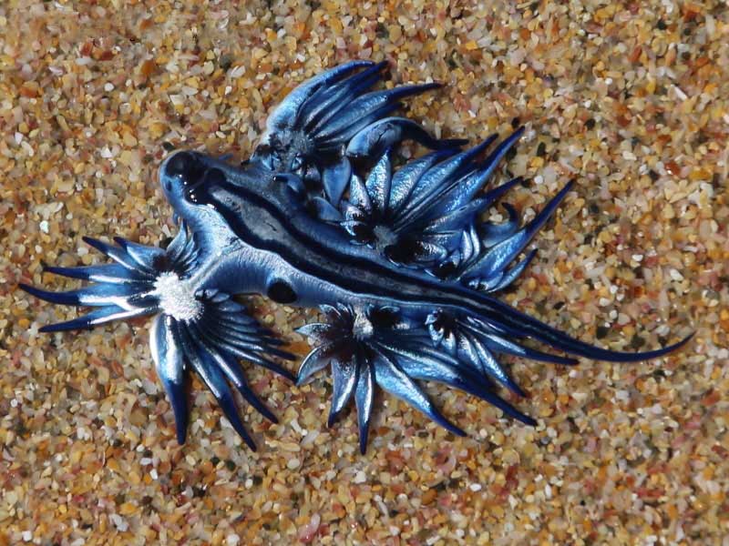
Washed up on Henderson Bay, Far North. Photo 3001219. 30mm. Reproduced courtesy of iNaturalist.nz ©tangatawhenua
Taxonomy
Family: GLAUCIDAE Full Classification: Genus Synonyms: =Dadone Gistel, 1848 Synonymised Names: =Doris radiata Gmelin, 1791 =Glaucus distichoicus d'Orbigny, 1837 =Glaucus flagellum Blumenblach, 1803 =Glaucus hexapterigius Cuvier, 1805 =Glaucus lineatus Reinhardt & Bergh, 1864 =Glaucus longicirrhus Reinhardt & Bergh, 1864 |
Details: Glaucus atlanticus Forster, 1777
Size/Grows to:
Animal 40mm
Distribution:
Washed ashore Hauraki Gulf, Muriwai Beach and Far North
Geographical Range:
A
Notes:
Species Links
Distribution Map
References and Publications
- Morley, M.S., Hayward, B.W. 2015 Intertidal records of 'sea slugs' (nudibranchs and allied opisthobranch gastropods) from northern North Island, New Zealand, Records of the Auckland Institute and Museum, 50 (p.77)
- Churchill, C.K., Valdés, Á., Foighil, D.Ó. 2014 Molecular and morphological systematics of neustonic nudibranchs (Mollusca : Gastropoda :Glaucidae :Glaucus), with descriptions of three new cryptic species, Invertebrate Systematics, 28 (p.174)
- Powell, A.W.B. 1979 New Zealand Mollusca: Marine, Land and Freshwater Shells, Collins, Auckland (p.290)
- Hole, D.M. Feb/1975 Seaborne Treasures, Matai Bay, Poirieria, 7(6) (p.115)
Key to Geographical Ranges

The symbols K.A.C.F.M.An. are used to indicate the geographical range of the species.
They have been adopted to give an approximation of the range of each species within New Zealand.
K=
Kermadec Islands
A=
Aupourian - Kaipara Harbour, north around North Cape, encompassing the Three Kings Islands and south to East Cape
C=
Cookian - Lower North Island and the northern part of the South Island
F=
Forsterian - Otago, Fiordland and Stewart Island
M=
Moriorian - Chatham Islands, Pitt Island
An=
Antipodean - Subantarctic Islands of New Zealand
Fw =
Freshwater
L =
Land
N =
North Island
S =
South Island
R =
Recent
Sf =
Subfossil
Fo =
Fossil
Recently Viewed
Compare Species (
/6)