Compare Anisodonta alata trigonia
| toggle to add to compare list |
Taxonomy
Family: BASTEROTIIDAE Full Classification: Mollusca (Phylum) > Bivalvia (Class) > Autobranchia (Subclass) > Heteroconchia (Infraclass) > Euhetrodonta (Subterclass) > Imparidentia (Superorder) > Galeommatida (Order) > Galeommatoidea (Superfamily) > Basterotiidae (Family) > Anisodonta (Genus) > alata trigonia (Species) Genus Synonyms: =Anisodonta (Anisodonta) Deshayes, 1857 accepted, alternate representation =Anisodonta (Austrosportella) Ponder, 1971 accepted, alternate representation =Anisodonta (Tahunanuia) Powell, 1952 accepted, alternate representation =Tahunanuia Powell, 1952 Synonymised Names: =Anisodonta (Tahunanuia) alata trigonia (Powell, 1952) accepted, alternate representation =Tahunanuia trigonia Powell, 1952 |
Images: Anisodonta alata trigonia (Powell, 1952)

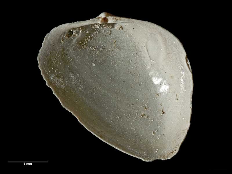
Holotype, dredged in Perseverance Harbour, Campbell Island, NZ (MA72202). 4.5mm. © Auckland Museum (CC-BY)
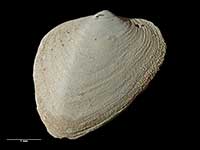
Holotype, dredged in Perseverance Harbour, Campbell Island, NZ (MA72202). 4.5mm. © Auckland Museum (CC-BY)
Taxonomy
Family: BASTEROTIIDAE Full Classification: Mollusca (Phylum) > Bivalvia (Class) > Autobranchia (Subclass) > Heteroconchia (Infraclass) > Euhetrodonta (Subterclass) > Imparidentia (Superorder) > Galeommatida (Order) > Galeommatoidea (Superfamily) > Basterotiidae (Family) > Anisodonta (Genus) > alata trigonia (Species) Genus Synonyms: =Anisodonta (Anisodonta) Deshayes, 1857 accepted, alternate representation =Anisodonta (Austrosportella) Ponder, 1971 accepted, alternate representation =Anisodonta (Tahunanuia) Powell, 1952 accepted, alternate representation =Tahunanuia Powell, 1952 Synonymised Names: =Anisodonta (Tahunanuia) alata trigonia (Powell, 1952) accepted, alternate representation =Tahunanuia trigonia Powell, 1952 |
Details: Anisodonta alata trigonia (Powell, 1952)
Size/Grows to:
Width 4.8mm, Height 3.5mm
Distribution:
Off Campbell Island
Geographical Range:
An
Notes:
Species Links
Distribution Map
References and Publications
- Powell, A.W.B. 1979 New Zealand Mollusca: Marine, Land and Freshwater Shells, Collins, Auckland (p.405)
- Powell, A.W.B. 1952 New Zealand Molluscan Systematics with Descriptions of New Species: Part 1, Records of the Auckland Institute and Museum, 4(3) (p.171) Original Description
Key to Geographical Ranges

The symbols K.A.C.F.M.An. are used to indicate the geographical range of the species.
They have been adopted to give an approximation of the range of each species within New Zealand.
K=
Kermadec Islands
A=
Aupourian - Kaipara Harbour, north around North Cape, encompassing the Three Kings Islands and south to East Cape
C=
Cookian - Lower North Island and the northern part of the South Island
F=
Forsterian - Otago, Fiordland and Stewart Island
M=
Moriorian - Chatham Islands, Pitt Island
An=
Antipodean - Subantarctic Islands of New Zealand
Fw =
Freshwater
L =
Land
N =
North Island
S =
South Island
R =
Recent
Sf =
Subfossil
Fo =
Fossil
Recently Viewed
Compare Species (
/6)