Compare Maurea maui
| toggle to add to compare list |
Taxonomy
Family: Subfamily: CALLIOSTOMATIDAE: CALLIOSTOMATINAE Full Classification: Mollusca (Phylum) > Gastropoda (Class) > Vetigastropoda (Subclass) > Trochida (Order) > Trochoidea (Superfamily) > Calliostomatidae (Family) > Calliostomatinae (Subfamily) > Maurea (Genus) > maui (Species) Genus Synonyms: =Alertalex Dell, 1956 =Calliostoma (Calliotropis) W.R.B. Oliver, 1926 =Calliostoma (Maurea) W.R.B. Oliver, 1926 =Calliostoma (Mauriella) W.R.B. Oliver, 1926 =Calliotropis W.R.B. Oliver, 1926 =Calotropis Thiele, 1929 =Maurea (Alertalex) Dell, 1956 =Maurea (Mucrinops) Finlay, 1926 =Mauriella W.R.B. Oliver, 1926 =Mucrinops Finlay, 1926 =Venustas Finlay, 1926 =Venustas (Mucrinops) Finlay, 1926 Synonymised Names: =Calliostoma (Maurea) maui B.A. Marshall, 1995 =Calliostoma maui B.A. Marshall, 1995 |
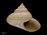
Images: Maurea maui (B.A. Marshall, 1995)

Holotype, collected 29 Sep 1976, Cook Strait Canyon, off Karori Rocks, NZ (M.087449). 31mm. © Museum of New Zealand Te Papa Tongarewa (CC-BY-NC-ND)
Taxonomy
Family: Subfamily: CALLIOSTOMATIDAE: CALLIOSTOMATINAE Full Classification: Mollusca (Phylum) > Gastropoda (Class) > Vetigastropoda (Subclass) > Trochida (Order) > Trochoidea (Superfamily) > Calliostomatidae (Family) > Calliostomatinae (Subfamily) > Maurea (Genus) > maui (Species) Genus Synonyms: =Alertalex Dell, 1956 =Calliostoma (Calliotropis) W.R.B. Oliver, 1926 =Calliostoma (Maurea) W.R.B. Oliver, 1926 =Calliostoma (Mauriella) W.R.B. Oliver, 1926 =Calliotropis W.R.B. Oliver, 1926 =Calotropis Thiele, 1929 =Maurea (Alertalex) Dell, 1956 =Maurea (Mucrinops) Finlay, 1926 =Mauriella W.R.B. Oliver, 1926 =Mucrinops Finlay, 1926 =Venustas Finlay, 1926 =Venustas (Mucrinops) Finlay, 1926 Synonymised Names: =Calliostoma (Maurea) maui B.A. Marshall, 1995 =Calliostoma maui B.A. Marshall, 1995 |
Details: Maurea maui (B.A. Marshall, 1995)
Size/Grows to:
Width 45mm, Height 42mm
Distribution:
Cook Strait, NE South Island, Chatham Rise, 140-490 metres
Geographical Range:
CM
Notes:
Species Links
Distribution Map
References and Publications
- Marshall, B.A. 1995 A revision of the Recent Calliostoma species of New Zealand (Mollusca: Gastropoda: Trochoidea), The Nautilus, 108(4) (p.106) Original Description
*98 © Museum of New Zealand Te Papa Tongarewa (CC-BY-NC-ND)
Key to Geographical Ranges

The symbols K.A.C.F.M.An. are used to indicate the geographical range of the species.
They have been adopted to give an approximation of the range of each species within New Zealand.
K=
Kermadec Islands
A=
Aupourian - Kaipara Harbour, north around North Cape, encompassing the Three Kings Islands and south to East Cape
C=
Cookian - Lower North Island and the northern part of the South Island
F=
Forsterian - Otago, Fiordland and Stewart Island
M=
Moriorian - Chatham Islands, Pitt Island
An=
Antipodean - Subantarctic Islands of New Zealand
Fw =
Freshwater
L =
Land
N =
North Island
S =
South Island
R =
Recent
Sf =
Subfossil
Fo =
Fossil
Compare Species (
/6)